
Thank you for supporting this site ❤️
Make a donation
Make a donation
Sattelhorn topographic map
Click on the map to display elevation.
Thank you for supporting this site ❤️
Make a donation
Make a donation
About this map
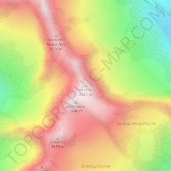
Name: Sattelhorn topographic map, elevation, terrain.
Location: Sattelhorn, Naters, Brig, Wallis, Switzerland (46.44360 8.00775 46.44370 8.00785)
Average elevation: 3,194 m
Minimum elevation: 2,583 m
Maximum elevation: 3,688 m
Thank you for supporting this site ❤️
Make a donation
Make a donation
Other topographic maps
Click on a map to view its topography, its elevation and its terrain.