
Make a donation
Ilford topographic map
Click on the map to display elevation.
Make a donation
About this map
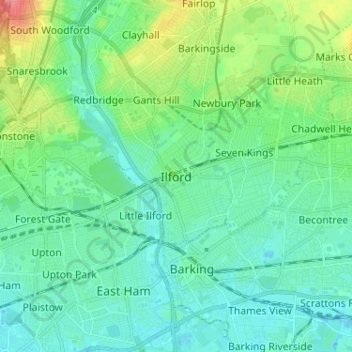
Name: Ilford topographic map, elevation, terrain.
Location: Ilford, Greater London, England, IG1 1DL, United Kingdom (51.51827 0.03117 51.59827 0.11117)
Average elevation: 16 m
Minimum elevation: -2 m
Maximum elevation: 67 m
Make a donation
Other topographic maps
Click on a map to view its topography, its elevation and its terrain.
Make a donation
Make a donation
Burnley
United Kingdom > England > Lancashire
The town lies in a natural three-forked valley at the confluence of the River Brun and the River Calder, surrounded by open fields, with wild moorland at higher altitudes. To the west of Burnley lie the towns of Padiham, Accrington and Blackburn, with Nelson and Colne to the north. The centre of the town…
Average elevation: 247 m
Aylesbury
United Kingdom > England > Aylesbury
Aylesbury is immediately southeast of the upper River Thame that flows past Thame to Dorchester on Thames and is partly sited on the two northernmost outcrops of Portland (lime)stone in England bisected by a small stream, Bear Brook which gives a relatively prominent position in relation to the terrain of all…
Average elevation: 84 m
Make a donation
Make a donation
Make a donation
South Downs National Park
United Kingdom > England > West Sussex
The South Downs National Park's chalk downland sets it apart from other national parks in Britain. However, almost a quarter (23%) of the national park consists of a quite different and strongly contrasting physiographic region, the western Weald, whose densely wooded hills and vales are based on an older…
Average elevation: 54 m
Make a donation
Stone
United Kingdom > England > Staffordshire
More recent research points to older, though no less interesting nor tangible, possibilities regarding its name and founding. Around Stone lie several Romano-British sites and it is not inconceivable that the name alludes to the stone remains of a bridge or milestone, perhaps continuing the Roman road from…
Average elevation: 107 m
Make a donation
The Weald
Neither the thin infertile sands of the High Weald or the wet sticky clays of the Low Weald are suited to intensive arable farming and the topography of the area often increases the difficulties. There are limited areas of fertile greensand which can be used for intensive vegetable growing, as in the valley of…
Average elevation: 41 m
Make a donation
Terrington St. Clement
United Kingdom > England > Norfolk > King's Lynn and West Norfolk
Average elevation: 2 m
Make a donation
Milburn
United Kingdom > England > Westmorland and Furness
From an agricultural perspective, however, the Geopark is simply an area of poorly drained grazing that becomes progressively less useful as its altitude increases. Nevertheless, the lower slopes of the inlier are still sufficiently valuable to be enclosed, largely with drystone walling, and are used for…
Average elevation: 320 m
Make a donation
Make a donation
Sudeley Castle
United Kingdom > England > Gloucestershire > Cheltenham > Sudeley
His elevation almost certainly came from his assistance in the suppression of the Wyatt rebellion.
Average elevation: 135 m
Make a donation
Ashwellthorpe and Fundenhall
United Kingdom > England > Norfolk > South Norfolk
Average elevation: 53 m
Make a donation
Make a donation
Make a donation
Pendragon Castle
United Kingdom > England > Westmorland and Furness > Outhgill
Average elevation: 345 m
Clearwater
United Kingdom > England > Gloucestershire > Cotswold District > Somerford Keynes
Average elevation: 88 m
Make a donation
Aston Subedge
United Kingdom > England > Gloucestershire > Cotswold District > Weston-sub-Edge
Average elevation: 101 m
West Yorkshire
Wakefield's Parish Church was raised to cathedral status in 1888 and after the elevation of Wakefield to diocese, Wakefield Council immediately sought city status and this was granted in July 1888. However the Industrial Revolution, which changed West and South Yorkshire significantly, led to the growth of…
Average elevation: 172 m
Cinderford
United Kingdom > England > Gloucestershire > Forest of Dean > Littledean
Average elevation: 173 m
Make a donation
Lostock Gralam
United Kingdom > England > Cheshire West and Chester > Lostock Gralam
Average elevation: 33 m
Make a donation
Make a donation
Make a donation
Make a donation
Make a donation
Make a donation
Make a donation
North Baddesley
United Kingdom > England > Hampshire > Test Valley > North Baddesley
Average elevation: 42 m
Make a donation