
Thank you for supporting this site ❤️
Make a donation
Make a donation
Dühren topographic map
Click on the map to display elevation.
Thank you for supporting this site ❤️
Make a donation
Make a donation
About this map
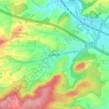
Name: Dühren topographic map, elevation, terrain.
Average elevation: 204 m
Minimum elevation: 150 m
Maximum elevation: 289 m
Thank you for supporting this site ❤️
Make a donation
Make a donation
Other topographic maps
Click on a map to view its topography, its elevation and its terrain.
Burg Steinsberg
Deutschland > Baden-Württemberg > Rhein-Neckar-Kreis > Sinsheim
Die Burg Steinsberg ist die zum Teil restaurierte Ruine einer mittelalterlichen Höhenburg im Ort Weiler, einem Stadtteil von Sinsheim im Rhein-Neckar-Kreis (Baden-Württemberg).
Average elevation: 246 m
Thank you for supporting this site ❤️
Make a donation
Make a donation
Waldangelloch
Deutschland > Baden-Württemberg > Rhein-Neckar-Kreis > Sinsheim
Average elevation: 229 m