
Thank you for supporting this site ❤️
Make a donation
Make a donation
Gästrike-Hammarby topographic map
Click on the map to display elevation.
Thank you for supporting this site ❤️
Make a donation
Make a donation
About this map
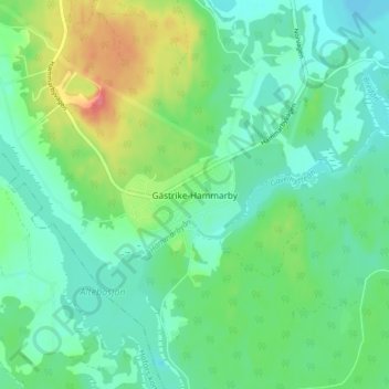
Name: Gästrike-Hammarby topographic map, elevation, terrain.
Location: Gästrike-Hammarby, Sandvikens kommun, Gävleborg County, Sweden (60.52506 16.55395 60.56506 16.59395)
Average elevation: 78 m
Minimum elevation: 58 m
Maximum elevation: 125 m
Thank you for supporting this site ❤️
Make a donation
Make a donation
Other topographic maps
Click on a map to view its topography, its elevation and its terrain.
Thank you for supporting this site ❤️
Make a donation
Make a donation
Thank you for supporting this site ❤️
Make a donation
Make a donation
Thank you for supporting this site ❤️
Make a donation
Make a donation