
Thank you for supporting this site ❤️
Make a donation
Make a donation
Langenhorn topographic map
Click on the map to display elevation.
Thank you for supporting this site ❤️
Make a donation
Make a donation
About this map
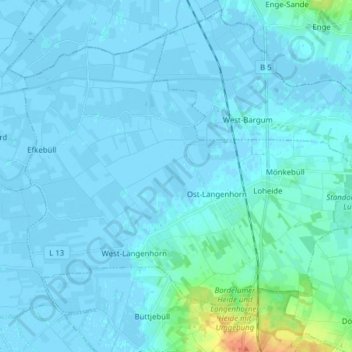
Name: Langenhorn topographic map, elevation, terrain.
Average elevation: 3 m
Minimum elevation: -4 m
Maximum elevation: 46 m
Thank you for supporting this site ❤️
Make a donation
Make a donation
Other topographic maps
Click on a map to view its topography, its elevation and its terrain.
Wenningstedt
Deutschland > Schleswig-Holstein > Nordfriesland
Wenningstedt bildet aufgrund seiner erheblich höheren Einwohner- und Gästebettenzahl das Zentrum der Gemeinde mit Gemeindebüro, Kurverwaltung und Einzelhandel.
Average elevation: 10 m