
Thank you for supporting this site ❤️
Make a donation
Make a donation
Carlisle topographic map
Click on the map to display elevation.
Thank you for supporting this site ❤️
Make a donation
Make a donation
About this map
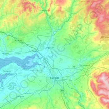
Name: Carlisle topographic map, elevation, terrain.
Location: Carlisle, Cumbria, England, United Kingdom (54.77615 -3.18281 55.18898 -2.48233)
Average elevation: 132 m
Minimum elevation: -1 m
Maximum elevation: 619 m
Thank you for supporting this site ❤️
Make a donation
Make a donation
Other topographic maps
Click on a map to view its topography, its elevation and its terrain.