
Thank you for supporting this site ❤️
Make a donation
Make a donation
Yaoundé topographic map
Click on the map to display elevation.
Thank you for supporting this site ❤️
Make a donation
Make a donation
Yaoundé
Yaoundé (UK: /jɑːˈʊndeɪ, -ˈuːn-/; US: /ˌjɑːʊnˈdeɪ/, French pronunciation: [ja.unde]) is the capital of Cameroon and, with a population of more than 2.8 million, the second-largest city in the country after the port city Douala. It lies in the Centre Region of the nation at an elevation of about 750 metres (2,500 ft) above sea level.
Thank you for supporting this site ❤️
Make a donation
Make a donation
About this map
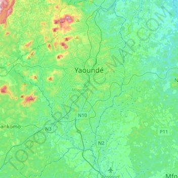
Name: Yaoundé topographic map, elevation, terrain.
Location: Yaoundé, Mfoundi, Centre, Cameroon (3.71340 11.41118 3.96920 11.57481)
Average elevation: 724 m
Minimum elevation: 603 m
Maximum elevation: 1,214 m
Thank you for supporting this site ❤️
Make a donation
Make a donation
Other topographic maps
Click on a map to view its topography, its elevation and its terrain.