
Thank you for supporting this site ❤️
Make a donation
Make a donation
Fort Bonifacio topographic map
Click on the map to display elevation.
Thank you for supporting this site ❤️
Make a donation
Make a donation
About this map
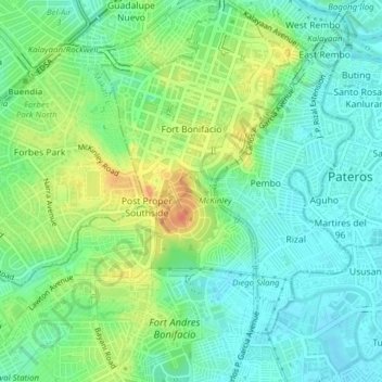
Name: Fort Bonifacio topographic map, elevation, terrain.
Location: Fort Bonifacio, Taguig, Metro Manila, 1634, Philippines (14.52450 121.02214 14.56213 121.06099)
Average elevation: 19 m
Minimum elevation: 2 m
Maximum elevation: 49 m
Thank you for supporting this site ❤️
Make a donation
Make a donation
Other topographic maps
Click on a map to view its topography, its elevation and its terrain.