
Thank you for supporting this site ❤️
Make a donation
Make a donation
Horse Island topographic map
Click on the map to display elevation.
Thank you for supporting this site ❤️
Make a donation
Make a donation
About this map
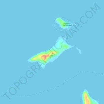
Name: Horse Island topographic map, elevation, terrain.
Location: Horse Island, Busuanga, Palawan, Mimaropa, 5317, Philippines (12.04257 119.89106 12.05116 119.90328)
Average elevation: 1 m
Minimum elevation: -4 m
Maximum elevation: 49 m
Thank you for supporting this site ❤️
Make a donation
Make a donation
Other topographic maps
Click on a map to view its topography, its elevation and its terrain.