
Holosiivskyi District topographic map
Interactive map
Click on the map to display elevation.
About this map
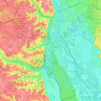
Name: Holosiivskyi District topographic map, elevation, terrain.
Location: Holosiivskyi District, Kyiv, Ukraine (50.21324 30.43027 50.44195 30.64732)
Average elevation: 128 m
Minimum elevation: 86 m
Maximum elevation: 208 m
Other topographic maps
Click on a map to view its topography, its elevation and its terrain.
Kyiv
Originally on the west bank, today Kyiv is located on both sides of the Dnieper, which flows southwards through the city towards the Black Sea. The older and higher western part of the city sits on numerous wooded hills (Kyiv Hills), with ravines and small rivers. Kyiv's geographical relief contributed to its…
Average elevation: 133 m