
Villa La Angostura topographic map
Interactive map
Click on the map to display elevation.
Villa La Angostura
The elevation of the city centre is about 790 m, the lake is at 765 m. Surrounding mountains range from 1,500 m to about 2,000 m (Cerro Bayo, right behind the city, is 1,782 m high).
About this map
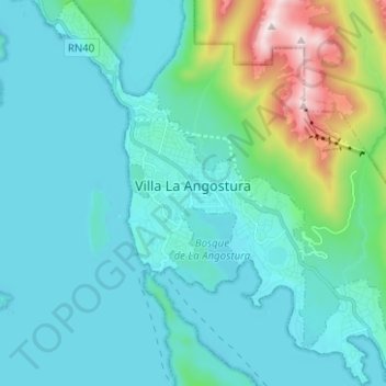
Name: Villa La Angostura topographic map, elevation, terrain.
Average elevation: 928 m
Minimum elevation: 759 m
Maximum elevation: 1,824 m