
Thank you for supporting this site ❤️
Make a donation
Make a donation
Al-ʿAbbāsiyyah Canal topographic map
Click on the map to display elevation.
Thank you for supporting this site ❤️
Make a donation
Make a donation
About this map
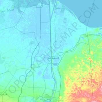
Name: Al-ʿAbbāsiyyah Canal topographic map, elevation, terrain.
Location: Al-ʿAbbāsiyyah Canal, Port Said, 41524, Egypt (30.58346 32.24480 31.23122 32.31484)
Average elevation: 16 m
Minimum elevation: -5 m
Maximum elevation: 157 m
Thank you for supporting this site ❤️
Make a donation
Make a donation
Other topographic maps
Click on a map to view its topography, its elevation and its terrain.
Thank you for supporting this site ❤️
Make a donation
Make a donation
Thank you for supporting this site ❤️
Make a donation
Make a donation