
Thank you for supporting this site ❤️
Make a donation
Make a donation
Lombardsijde topographic map
Click on the map to display elevation.
Thank you for supporting this site ❤️
Make a donation
Make a donation
About this map
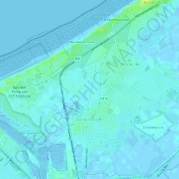
Name: Lombardsijde topographic map, elevation, terrain.
Location: Lombardsijde, Middelkerke, Oostende, West-Vlaanderen, België (51.13841 2.74612 51.17073 2.77890)
Average elevation: 2 m
Minimum elevation: -4 m
Maximum elevation: 18 m
Thank you for supporting this site ❤️
Make a donation
Make a donation
Other topographic maps
Click on a map to view its topography, its elevation and its terrain.