
Kodagu topographic map
Interactive map
Click on the map to display elevation.
Kodagu
Kodagu is located on the eastern slopes of the Western Ghats. It has a geographical area of 4,102 km2 (1,584 sq mi). The district is bordered by Dakshina Kannada district to the northwest, Hassan district to the north, Mysore district to the east, Kasaragod district in west and Kannur district of Kerala to the southwest, and Wayanad district of Kerala to the south. It is a hilly district, the lowest elevation of which is 120 metres (390 ft) above sea-level. The highest peak, Tadiandamol, rises to 1,750 metres (5,740 ft), with Pushpagiri, the second highest, at 1,715 metres (5,627 ft). The main river in Kodagu is the Kaveri (Cauvery), which originates at Talakaveri, located on the eastern side of the Western Ghats, and with its tributaries, drains the greater part of Kodagu.
About this map
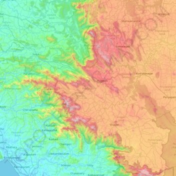
Name: Kodagu topographic map, elevation, terrain.
Location: Kodagu, Karnataka, India (11.93123 75.36544 12.83349 76.18857)
Average elevation: 561 m
Minimum elevation: -3 m
Maximum elevation: 1,713 m
Other topographic maps
Click on a map to view its topography, its elevation and its terrain.
Kalaburagi
India > Karnataka > Kalaburagi taluku > Kalaburagi
The entire district is on the Deccan Plateau, and the elevation ranges from 300 to 750 m above MSL. Two main rivers, the Krishna and Bhima, flow through the district. The predominant soil type is black soil. The district has many tanks, which irrigate the land along with the river. The Upper Krishna Project is…
Average elevation: 465 m