
Make a donation
Zapopan topographic map
Click on the map to display elevation.
Make a donation
Zapopan
Most of the municipality is flat with another quarter having rolling hills. Altitude varies from 1,500 to 2,000 metres (4,900 to 6,600 ft) above sea level. The main elevations are in the Sierra de la Primavera and include Nejahuete, Tajo and El Chapulin. Superficial water flows mostly in arroyos east to the Grande or Santiago River. In the center of the municipality there are three dams called the Copalita, the Santa Lucia and the San Jose. Winters here are mild and usually are noticeable only in the higher elevations. Average year-round temperature is 22C with highs of 36C and lows of 11C. Rain principally falls from June to October. Vegetation in the municipality varies from pines and holm oaks in the Sierra de la Primavera and species such as jonote (Heliocarpus appendiculatus), strawberry trees and nopals in the lower elevations. While wildlife has nearly disappeared from this area, the Bosque el Nixticuil on the northern edge of the urban sprawl has been designated as a protected natural area and still is home to many mammals, reptiles, amphibians, birds and insects.
Make a donation
About this map
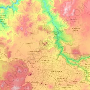
Name: Zapopan topographic map, elevation, terrain.
Location: Zapopan, Jalisco, Mexico (20.58479 -103.66503 20.99824 -103.30597)
Average elevation: 1,586 m
Minimum elevation: 730 m
Maximum elevation: 2,377 m
Make a donation
Other topographic maps
Click on a map to view its topography, its elevation and its terrain.
Ajijic
The Chapala Lake basin has a year-round average temperature of about 19 °C (66 °F). Due to Ajijic's tropical latitude and relatively high elevation, it is seldom unpleasantly hot or humid. The rainy season begins in June and lasts until October. The average rainfall is 793 millimetres (31.2 in). Even during…
Average elevation: 1,738 m
Make a donation
Tequila
Tequila is one of the 124 municipalities of Jalisco, located just west of the center of the state. Its territory extends for 1689.11km2, with elevations that vary between 700 and 2,900 meters above sea level. The municipality borders with the main metropolitan region of Guadalajara to the east (Zapopan), and…
Average elevation: 1,267 m
Make a donation
Make a donation
Make a donation
Capilla de Guadalupe
Mexico > Jalisco > Tepatitlán de Morelos > Capilla de Guadalupe
Average elevation: 2,049 m
Make a donation