
Thank you for supporting this site ❤️
Make a donation
Make a donation
Hundelgem topographic map
Click on the map to display elevation.
Thank you for supporting this site ❤️
Make a donation
Make a donation
Hundelgem
Hundelgem ligt in Zandlemig Vlaanderen op een hoogte van 25-58 meter. In het oosten loopt de Passemaregracht met daarop de Pedes molen. In het zuiden loopt de Zwalm.
Thank you for supporting this site ❤️
Make a donation
Make a donation
About this map
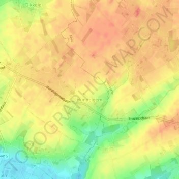
Name: Hundelgem topographic map, elevation, terrain.
Average elevation: 47 m
Minimum elevation: 16 m
Maximum elevation: 62 m
Thank you for supporting this site ❤️
Make a donation
Make a donation
Other topographic maps
Click on a map to view its topography, its elevation and its terrain.