
Make a donation
Waterford Township topographic map
Click on the map to display elevation.
Make a donation
Waterford Township
Like the rest of Southeast Michigan, Waterford Township has a continental climate. It has a higher elevation than Detroit (982 feet (299 m) compared to 585 feet (178 m)), and therefore the township is somewhat cooler than Detroit and other nearby cities. It is moderately cold in the winter with varied snowfall throughout. Spring varies from warm by day to cool at night. The township's warmest weather occurs in the summer with temperatures in the eighty to ninety degree range and typically high humidity. Summer is also the wettest season in the area. In recent years, Waterford Township has seen a few 100-plus-degree days. Fall starts warm, but November ends with high temperatures barely above freezing.
Make a donation
About this map
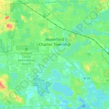
Name: Waterford Township topographic map, elevation, terrain.
Location: Waterford Township, Oakland County, Michigan, United States (42.61336 -83.44614 42.70592 -83.32540)
Average elevation: 294 m
Minimum elevation: 279 m
Maximum elevation: 341 m
Make a donation
Other topographic maps
Click on a map to view its topography, its elevation and its terrain.
Make a donation
Jossman Acres
United States > Michigan > Oakland County > Springfield Charter Township
Average elevation: 324 m
Make a donation
Oxbow
United States > Michigan > Oakland County > White Lake Charter Township
Average elevation: 293 m
Union Lake
United States > Michigan > Oakland County > White Lake Charter Township
Average elevation: 290 m
Carpenter Lake Nature Preserve
United States > Michigan > Oakland County > Southfield
Average elevation: 207 m
Make a donation
Dollar Lake
United States > Michigan > Oakland County > Independence Charter Township
Average elevation: 306 m
Cranberry Lake
United States > Michigan > Oakland County > White Lake Charter Township
Average elevation: 295 m
Make a donation
North Farmington
United States > Michigan > Oakland County > Farmington Hills
Average elevation: 277 m
Huron Heights
United States > Michigan > Oakland County > Waterford Charter Township
Average elevation: 292 m
Davisburg
United States > Michigan > Oakland County > Springfield Charter Township
Average elevation: 309 m
Make a donation
Rochester Hills
United States > Michigan > Oakland County > Rochester Hills
Rochester Hills is bordered to the north by Oakland Charter Township along Dutton Road, to the south by the city of Troy along South Boulevard, to the east by Shelby Township in Macomb County along Dequindre Road, and to the west by the city of Auburn Hills along part of Adams Road. Rochester Hills is also…
Average elevation: 246 m