
Thank you for supporting this site ❤️
Make a donation
Make a donation
Sarnen topographic map
Click on the map to display elevation.
Thank you for supporting this site ❤️
Make a donation
Make a donation
Sarnen
Sarnen is situated at an altitude of 471 m (1,545 ft) on the northern shore of Lake Sarnen (German: Sarnersee) along the outflow of the Sarner Aa. Lake Sarnen covers approximately an area of 7.5 km2 (2.9 sq mi). The town is surrounded by mountain chains and a protected bog can be found nearby. The most well-known mountain close to Sarnen is Mount Pilatus with an elevation of 2,132 m (6,995 ft).
Thank you for supporting this site ❤️
Make a donation
Make a donation
About this map
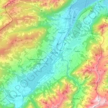
Name: Sarnen topographic map, elevation, terrain.
Location: Sarnen, Obwalden, Switzerland (46.85422 8.06700 46.93346 8.27766)
Average elevation: 1,040 m
Minimum elevation: 428 m
Maximum elevation: 2,354 m
Thank you for supporting this site ❤️
Make a donation
Make a donation
Other topographic maps
Click on a map to view its topography, its elevation and its terrain.