
Thank you for supporting this site ❤️
Make a donation
Make a donation
Long Mountain topographic map
Click on the map to display elevation.
Thank you for supporting this site ❤️
Make a donation
Make a donation
About this map
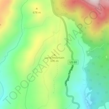
Name: Long Mountain topographic map, elevation, terrain.
Location: Long Mountain, Amherst County, Virginia, United States (37.71370 -79.25147 37.71380 -79.25137)
Average elevation: 567 m
Minimum elevation: 357 m
Maximum elevation: 906 m
Thank you for supporting this site ❤️
Make a donation
Make a donation