Thank you for supporting this site ❤️
Make a donation
Make a donation
Chittlehamholt topographic map
Click on the map to display elevation.
Thank you for supporting this site ❤️
Make a donation
Make a donation
About this map
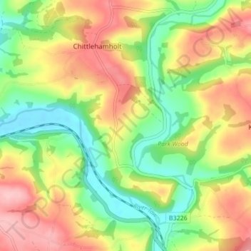
Name: Chittlehamholt topographic map, elevation, terrain.
Location: Chittlehamholt, North Devon, Devon, England, United Kingdom (50.94218 -3.96651 50.97612 -3.89818)
Average elevation: 103 m
Minimum elevation: 30 m
Maximum elevation: 187 m
Thank you for supporting this site ❤️
Make a donation
Make a donation
Other topographic maps
Click on a map to view its topography, its elevation and its terrain.
Middle Haxton
United Kingdom > England > Devon > North Devon > Bratton Fleming
Average elevation: 210 m
Thank you for supporting this site ❤️
Make a donation
Make a donation
Thank you for supporting this site ❤️
Make a donation
Make a donation
Thank you for supporting this site ❤️
Make a donation
Make a donation
Thank you for supporting this site ❤️
Make a donation
Make a donation
Thank you for supporting this site ❤️
Make a donation
Make a donation
Thank you for supporting this site ❤️
Make a donation
Make a donation
Thank you for supporting this site ❤️
Make a donation
Make a donation
Thank you for supporting this site ❤️
Make a donation
Make a donation
Thank you for supporting this site ❤️
Make a donation
Make a donation
