
Thank you for supporting this site ❤️
Make a donation
Make a donation
Motutapu Island topographic map
Click on the map to display elevation.
Thank you for supporting this site ❤️
Make a donation
Make a donation
About this map
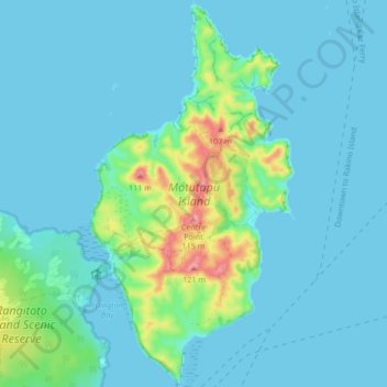
Name: Motutapu Island topographic map, elevation, terrain.
Location: Motutapu Island, Waiheke, Auckland, New Zealand (-36.79707 174.89289 -36.72958 174.93764)
Average elevation: 18 m
Minimum elevation: 0 m
Maximum elevation: 119 m
Thank you for supporting this site ❤️
Make a donation
Make a donation
Other topographic maps
Click on a map to view its topography, its elevation and its terrain.