
Thank you for supporting this site ❤️
Make a donation
Make a donation
El Karia topographic map
Click on the map to display elevation.
Thank you for supporting this site ❤️
Make a donation
Make a donation
About this map
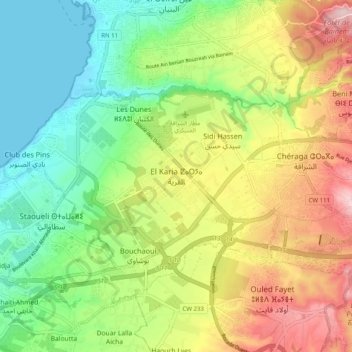
Name: El Karia topographic map, elevation, terrain.
Location: El Karia, Chéraga, Chéraga District, Algiers, 16084, Algeria (36.72345 2.88363 36.80345 2.96363)
Average elevation: 113 m
Minimum elevation: 0 m
Maximum elevation: 281 m
Thank you for supporting this site ❤️
Make a donation
Make a donation
Other topographic maps
Click on a map to view its topography, its elevation and its terrain.