
香港島 topographic map
Interactive map
Click on the map to display elevation.
About this map
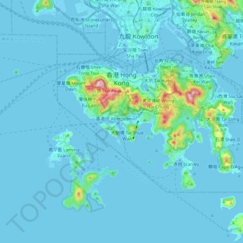
Name: 香港島 topographic map, elevation, terrain.
Location: 香港島, 香港, 中国 (22.19265 114.10988 22.30028 114.30905)
Average elevation: 36 m
Minimum elevation: -7 m
Maximum elevation: 532 m
香港島(英語:Hong Kong Island),又稱香港,港島,港島區或香港區,古稱范春州、紅香爐,與九龍和新界同為香港三大地域之一。面積約78.65平方公里,最高峰是太平山,海拔552米,為境內第二大島嶼。香港島屬萬山群島的一部份。香港島是香港開埠時最早發展的地區,當1842年香港成為英國殖民地而維多利亞城又未落成時,位於港島南區的赤柱是當時的行政中心。在英國殖民地初期,香港島北部人口密集,並劃為維多利亞城。香港島與九龍半島由維多利亞港分隔,海岸是昔日貿易船隻停泊的地方。
Other topographic maps
Click on a map to view its topography, its elevation and its terrain.