Geolocate

Fako topographic map

Interactive map

Click on the map to display elevation.

About this map

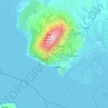
Name: Fako topographic map, elevation, terrain.

Location: Fako, Southwest, Cameroon (3.74371 8.79192 4.46054 9.55541)

Average elevation: 232 m

Minimum elevation: -5 m

Maximum elevation: 4,007 m

Other topographic maps

Click on a map to view its topography, its elevation and its terrain.

Oyi

Cameroon > Southwest > Manyu > Akwaya

Average elevation: 86 m

Meme

Cameroon > Southwest > Konye

Average elevation: 244 m

Aler

Cameroon > Southwest > Tinto

Average elevation: 227 m

Meme

Cameroon > Southwest > Bamusso

Average elevation: 137 m

Mungo

Cameroon > Southwest

Average elevation: 410 m

Mount Cameroon

Cameroon > Southwest

Average elevation: 3,645 m