
Thank you for supporting this site ❤️
Make a donation
Make a donation
Berrysville topographic map
Click on the map to display elevation.
Thank you for supporting this site ❤️
Make a donation
Make a donation
About this map
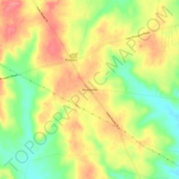
Name: Berrysville topographic map, elevation, terrain.
Location: Berrysville, Highland County, Ohio, 45133, United States (39.10840 -83.57853 39.14840 -83.53853)
Average elevation: 310 m
Minimum elevation: 267 m
Maximum elevation: 345 m
Thank you for supporting this site ❤️
Make a donation
Make a donation
Other topographic maps
Click on a map to view its topography, its elevation and its terrain.