
Batag Island topographic map
Interactive map
Click on the map to display elevation.
About this map
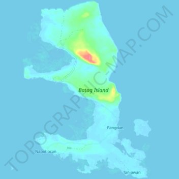
Name: Batag Island topographic map, elevation, terrain.
Location: Batag Island, Northern Samar, Eastern Visayas, Philippines (12.60184 125.02807 12.68640 125.09174)
Average elevation: 3 m
Minimum elevation: -4 m
Maximum elevation: 72 m
Other topographic maps
Click on a map to view its topography, its elevation and its terrain.
Catubig
Catubig, Northern Samar, Eastern Visayas, Philippines
Average elevation: 41 m
Macagtas
Philippines > Northern Samar > Catarman
Macagtas, Catarman, Northern Samar, Eastern Visayas, 6400, Philippines
Average elevation: 15 m
Landusan
Philippines > Northern Samar > Capul
Landusan, Capul, Northern Samar, Eastern Visayas, 6408, Philippines
Average elevation: 21 m
Talisay
Talisay, Northern Samar, Eastern Visayas, 6400, Philippines
Average elevation: 3 m
Talisay
Talisay, Northern Samar, Eastern Visayas, 6411, Philippines
Average elevation: 5 m
Lawaan
Lawaan, Northern Samar, Eastern Visayas, Philippines
Average elevation: 6 m
Biri Larosa Protected Landscape and Seascape
Philippines > Northern Samar > Biri
Biri Larosa Protected Landscape and Seascape, Biri, Northern Samar, Eastern Visayas, Philippines
Average elevation: 12 m
Bobolusan
Bobolusan, Northern Samar, Eastern Visayas, Philippines
Average elevation: 8 m
Dancalan
Philippines > Northern Samar > San Isidro > Dancalan
Dancalan, San Isidro, Northern Samar, Eastern Visayas, 6401, Philippines
Average elevation: 8 m
Catarman
Catarman, Northern Samar, Eastern Visayas, 6400, Philippines
Average elevation: 50 m
Polangi
Philippines > Northern Samar > Catarman > Polangi
Polangi, Catarman, Northern Samar, Eastern Visayas, Philippines
Average elevation: 32 m
Catarman
Philippines > Northern Samar > Catarman > Catarman
Catarman, Northern Samar, Eastern Visayas, 6400, Philippines
Average elevation: 11 m
Catubig River
Catubig River, Northern Samar, Eastern Visayas, Philippines
Average elevation: 38 m
Capul Island
Philippines > Northern Samar > Capul
Capul Island, Capul, Northern Samar, Eastern Visayas, 6408, Philippines
Average elevation: 14 m
Gamay
Philippines > Northern Samar > Gamay
Gamay, Northern Samar, Eastern Visayas, Philippines
Average elevation: 16 m
Victoria
Philippines > Northern Samar > Victoria
Victoria, Northern Samar, Eastern Visayas, 6406, Philippines
Average elevation: 43 m
San Jose
Philippines > Northern Samar > San Jose
San Jose, Northern Samar, Eastern Visayas, Philippines
Average elevation: 15 m
Rosario
Philippines > Northern Samar > Rosario
Rosario, Northern Samar, Eastern Visayas, 6416, Philippines
Average elevation: 28 m
Biri Island
Philippines > Northern Samar > Biri
Biri Island, Biri, Northern Samar, Eastern Visayas, Philippines
Average elevation: 14 m
San Roque
Philippines > Northern Samar > San Roque
San Roque, Northern Samar, Eastern Visayas, Philippines
Average elevation: 11 m
Silvino Lobos
Philippines > Northern Samar > Silvino Lobos
Silvino Lobos, Northern Samar, Eastern Visayas, Philippines
Average elevation: 95 m
Baryo san San Isdro
Philippines > Northern Samar > Baryo san San Isdro
Baryo san San Isdro, Northern Samar, Eastern Visayas, Philippines
Average elevation: 40 m
Capul
Capul, Northern Samar, Eastern Visayas, 6408, Philippines
Average elevation: 5 m
Lavezares
Philippines > Northern Samar > Lavezares > Lavezares
Lavezares, Northern Samar, Eastern Visayas, 6404, Philippines
Average elevation: 17 m
Brgy. Cawayan
Philippines > Northern Samar > Brgy. Cawayan
Brgy. Cawayan, Northern Samar, Eastern Visayas, 6400, Philippines
Average elevation: 3 m
Osmeña
Philippines > Northern Samar > Osmeña
Osmeña, Northern Samar, Eastern Visayas, 6421, Philippines
Average elevation: 48 m
Medio Island
Philippines > Northern Samar > Maragat
Medio Island, Maragat, San Vicente, Northern Samar, Eastern Visayas, Philippines
Average elevation: 2 m
San Bernardino Islands
San Bernardino Islands, Biri, Northern Samar, Eastern Visayas, Philippines
Average elevation: 33 m
Darsena Island
Darsena Island, San Vicente, Northern Samar, Eastern Visayas, Philippines
Average elevation: 16 m
San Jose
Philippines > Northern Samar > San Jose
San Jose, Northern Samar, Eastern Visayas, Philippines
Average elevation: 121 m
Aguada Island
Aguada Island, San Vicente, Northern Samar, Eastern Visayas, Philippines
Average elevation: 26 m
Escarpada Island
Escarpada Island, San Vicente, Northern Samar, Eastern Visayas, Philippines
Average elevation: 18 m
Imelda
Philippines > Northern Samar > Imelda
Imelda, Northern Samar, Eastern Visayas, Philippines
Average elevation: 32 m
Macarite Island
Macarite Island, Biri, Northern Samar, Eastern Visayas, Philippines
Average elevation: 5 m
Cahayagan Island
Cahayagan Island, Northern Samar, Eastern Visayas, Philippines
Average elevation: 2 m
Allen
Allen, Northern Samar, Eastern Visayas, 6405, Philippines
Average elevation: 33 m
Magesang Island
Magesang Island, Biri, Northern Samar, Eastern Visayas, Philippines
Average elevation: 4 m