
Thank you for supporting this site ❤️
Make a donation
Make a donation
Martim Longo topographic map
Click on the map to display elevation.
Thank you for supporting this site ❤️
Make a donation
Make a donation
About this map
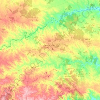
Name: Martim Longo topographic map, elevation, terrain.
Location: Martim Longo, Alcoutim, Faro, Algarve, Portugal (37.37416 -7.89684 37.48778 -7.67559)
Average elevation: 244 m
Minimum elevation: 86 m
Maximum elevation: 411 m
Thank you for supporting this site ❤️
Make a donation
Make a donation