
Thank you for supporting this site ❤️
Make a donation
Make a donation
Lowesville topographic map
Click on the map to display elevation.
Thank you for supporting this site ❤️
Make a donation
Make a donation
About this map
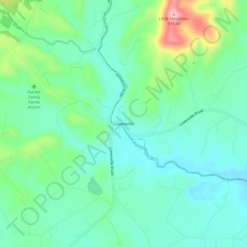
Name: Lowesville topographic map, elevation, terrain.
Location: Lowesville, Nelson County, Virginia, 24512, United States (37.69903 -79.08475 37.73903 -79.04475)
Average elevation: 251 m
Minimum elevation: 202 m
Maximum elevation: 390 m
Thank you for supporting this site ❤️
Make a donation
Make a donation
Other topographic maps
Click on a map to view its topography, its elevation and its terrain.
Thank you for supporting this site ❤️
Make a donation
Make a donation
Thank you for supporting this site ❤️
Make a donation
Make a donation