
Make a donation
Snoqualmie Pass topographic map
Click on the map to display elevation.
Make a donation
Snoqualmie Pass
Due to its elevation, Snoqualmie Pass experiences significantly lower temperatures than Seattle, and receives much more precipitation, much of it being snow. Snoqualmie Pass has a humid continental climate (Koppen: Dsb bordering Csb) with cold, very wet and snowy winters, and mild to warm, relatively dry summers.
Make a donation
About this map
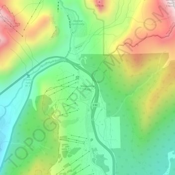
Name: Snoqualmie Pass topographic map, elevation, terrain.
Average elevation: 1,048 m
Minimum elevation: 662 m
Maximum elevation: 1,698 m
Make a donation
Other topographic maps
Click on a map to view its topography, its elevation and its terrain.
Make a donation
Lake Marcel
United States > Washington > King County
Lake Marcel is at an altitude of 295 feet (90 m) above sea level. The lake sits in a bowl at the top of Stillwater Hill on the east side of the Snoqualmie Valley, north of Carnation. It has two main areas of water connected by a channel, and several peninsular features make an extensive shoreline around the…
Average elevation: 110 m
Make a donation
Make a donation
Snoqualmie River
United States > Washington > King County
The Middle Fork Valley is a popular recreational area since it is accessible during the winter due to its low altitude and close proximity to Seattle. For many years the Middle Fork Road extended 24 miles to Hardscrabble Creek, but was gated at Dingford Creek in June 2007, 18 miles in. The gate at Dingford…
Average elevation: 212 m
Muckleshoot Tribe Reservation
United States > Washington > King County > Auburn
Average elevation: 163 m
Clyde Hill
United States > Washington > King County
The top elevation is close to 375 feet. There are approximately 21 miles of public roadways in Clyde Hill.
Average elevation: 48 m
Make a donation
Make a donation
Make a donation
Mercer Island
United States > Washington > King County > Mercer Island
Mercer Island City Hall is located at 47°34′39″N 122°12′43.2″W / 47.57750°N 122.212000°W / 47.57750; -122.212000 (47.5775, -122.212). The peak elevation in the city is about 338 feet (103 m), near the center of the island.
Average elevation: 39 m
Make a donation
Donnie Chin International Children’s Park
United States > Washington > King County > Seattle
Average elevation: 43 m
West Tiger Mountain Natural Resource Conservation Area
United States > Washington > King County > Issaquah
Average elevation: 101 m
Make a donation