
Thank you for supporting this site ❤️
Make a donation
Make a donation
Ohey topographic map
Click on the map to display elevation.
Thank you for supporting this site ❤️
Make a donation
Make a donation
Ohey
Ohey is een plaats en gemeente in de provincie Namen in België. De gemeente telt iets meer dan 5.000 inwoners en ligt op een hoogte van 259 meter.
Thank you for supporting this site ❤️
Make a donation
Make a donation
About this map
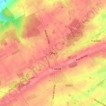
Name: Ohey topographic map, elevation, terrain.
Location: Ohey, Namen, Wallonië, 5350, België (50.41591 5.10384 50.45591 5.14384)
Average elevation: 259 m
Minimum elevation: 191 m
Maximum elevation: 285 m
Thank you for supporting this site ❤️
Make a donation
Make a donation