
Thank you for supporting this site ❤️
Make a donation
Make a donation
Bismarck topographic map
Click on the map to display elevation.
Thank you for supporting this site ❤️
Make a donation
Make a donation
About this map
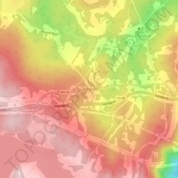
Name: Bismarck topographic map, elevation, terrain.
Location: Bismarck, Grant County, West Virginia, 26739, United States (39.19788 -79.25309 39.23788 -79.21309)
Average elevation: 925 m
Minimum elevation: 729 m
Maximum elevation: 1,023 m
Thank you for supporting this site ❤️
Make a donation
Make a donation
Other topographic maps
Click on a map to view its topography, its elevation and its terrain.