
Thank you for supporting this site ❤️
Make a donation
Make a donation
Knight Island topographic map
Click on the map to display elevation.
Thank you for supporting this site ❤️
Make a donation
Make a donation
About this map
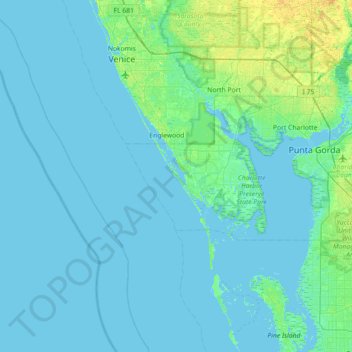
Name: Knight Island topographic map, elevation, terrain.
Average elevation: 2 m
Minimum elevation: -2 m
Maximum elevation: 17 m
Thank you for supporting this site ❤️
Make a donation
Make a donation
Other topographic maps
Click on a map to view its topography, its elevation and its terrain.
Gilcrest Park
United States > Florida > Charlotte County > Punta Gorda > Fishermens Village
Average elevation: 2 m
Ainger Creek Park
United States > Florida > Charlotte County > Englewood > New Point Comfort
Average elevation: 3 m
Thank you for supporting this site ❤️
Make a donation
Make a donation
Harbour Heights
United States > Florida > Charlotte County > Punta Gorda > Harbour Heights
Average elevation: 4 m