
Thank you for supporting this site ❤️
Make a donation
Make a donation
Little Aston topographic map
Click on the map to display elevation.
Thank you for supporting this site ❤️
Make a donation
Make a donation
About this map
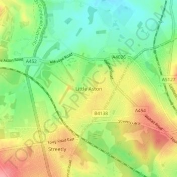
Name: Little Aston topographic map, elevation, terrain.
Average elevation: 142 m
Minimum elevation: 105 m
Maximum elevation: 192 m
Thank you for supporting this site ❤️
Make a donation
Make a donation
Other topographic maps
Click on a map to view its topography, its elevation and its terrain.
Drayton Bassett
United Kingdom > England > Staffordshire > Lichfield > Drayton Basset
Average elevation: 83 m