
Thank you for supporting this site ❤️
Make a donation
Make a donation
Kaltes Feld topographic map
Click on the map to display elevation.
Thank you for supporting this site ❤️
Make a donation
Make a donation
Kaltes Feld
Das Kalte Feld ist mit 781,1 m ü. NHN die höchste Erhebung in Ostwürttemberg. Die nächste höhere Erhebung ist der 23 km südwestlich gelegene Boßler.
Thank you for supporting this site ❤️
Make a donation
Make a donation
About this map
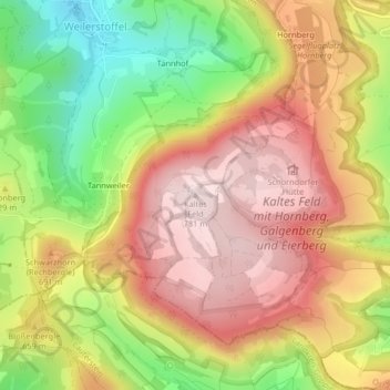
Name: Kaltes Feld topographic map, elevation, terrain.
Average elevation: 628 m
Minimum elevation: 433 m
Maximum elevation: 782 m
Thank you for supporting this site ❤️
Make a donation
Make a donation