
Make a donation
Edna Lake topographic map
Click on the map to display elevation.
Make a donation
About this map
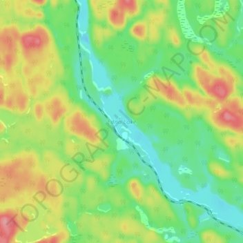
Name: Edna Lake topographic map, elevation, terrain.
Average elevation: 413 m
Minimum elevation: 372 m
Maximum elevation: 473 m
Make a donation
Other topographic maps
Click on a map to view its topography, its elevation and its terrain.
Halfway Lake Provincial Park
Canada > Ontario > Sudbury District > Unorganized North Sudbury
Average elevation: 440 m
Make a donation
Murdock River
Canada > Ontario > Sudbury District > Unorganized North Sudbury
Average elevation: 224 m
Chapleau River
Canada > Ontario > Sudbury District > Unorganized North Sudbury
Average elevation: 441 m
Make a donation
Whitefish Falls
Canada > Ontario > Sudbury District > Unorganized North Sudbury
Average elevation: 205 m
Spanish Chutes
Canada > Ontario > Sudbury District > Unorganized North Sudbury
Average elevation: 425 m
Ishpatina Ridge Fire Tower
Canada > Ontario > Sudbury District > Unorganized North Sudbury
Average elevation: 545 m
Make a donation
Willisville
Canada > Ontario > Sudbury District > Unorganized North Sudbury > Whitefish Falls
Average elevation: 219 m
Sandcherry Creek
Canada > Ontario > Sudbury District > Unorganized North Sudbury
Average elevation: 423 m
Make a donation
Whitefish River
Canada > Ontario > Sudbury District > Unorganized North Sudbury > Whitefish Falls
Average elevation: 195 m
Redstone Lake
Canada > Ontario > Sudbury District > Unorganized North Sudbury
Average elevation: 361 m
Make a donation
Chiniguchi River
Canada > Ontario > Sudbury District > Unorganized North Sudbury
Average elevation: 260 m
Make a donation