
Thank you for supporting this site ❤️
Make a donation
Make a donation
La Jurière topographic map
Click on the map to display elevation.
Thank you for supporting this site ❤️
Make a donation
Make a donation
About this map
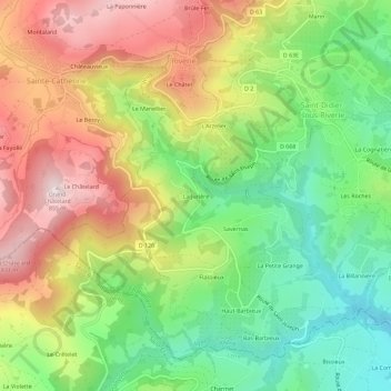
Name: La Jurière topographic map, elevation, terrain.
Average elevation: 567 m
Minimum elevation: 336 m
Maximum elevation: 847 m
Thank you for supporting this site ❤️
Make a donation
Make a donation
Other topographic maps
Click on a map to view its topography, its elevation and its terrain.
69440
France > Auvergne-Rhône-Alpes > Rhône > Chabanière > Saint-Didier-sous-Riverie > Verzieux
Average elevation: 499 m