
Make a donation
Knockawarriga topographic map
Click on the map to display elevation.
Make a donation
About this map
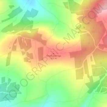
Name: Knockawarriga topographic map, elevation, terrain.
Average elevation: 247 m
Minimum elevation: 166 m
Maximum elevation: 327 m
Make a donation
Other topographic maps
Click on a map to view its topography, its elevation and its terrain.
Newcastle West
Ireland > County Limerick > The Municipal District of Newcastle West
Average elevation: 58 m
Cloonsherick
Ireland > County Limerick > The Municipal District of Newcastle West
Average elevation: 65 m
Make a donation
Newcastle
Ireland > County Limerick > The Municipal District of Newcastle West
Average elevation: 92 m
Churchtown
Ireland > County Limerick > The Municipal District of Newcastle West
Average elevation: 66 m
Cappanihane
Ireland > County Limerick > The Municipal District of Newcastle West
Average elevation: 102 m
Make a donation
Coolacokery
Ireland > County Limerick > The Municipal District of Newcastle West
Average elevation: 52 m
Crataloe West
Ireland > County Limerick > The Municipal District of Newcastle West
Average elevation: 153 m
Make a donation
Crataloe East
Ireland > County Limerick > The Municipal District of Newcastle West
Average elevation: 184 m
Ballaghbehy
Ireland > County Limerick > The Municipal District of Newcastle West
Average elevation: 135 m
Ballyduhig
Ireland > County Limerick > The Municipal District of Newcastle West
Average elevation: 114 m
Make a donation