Long Lake topographic map
Interactive map
Click on the map to display elevation.
About this map
![Long Lake topographic map, elevation, terrain](/pub/maps/way/d914/m2nnb1h/thumbnail.jpg)
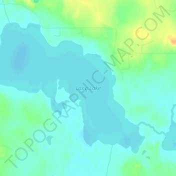
Name: Long Lake topographic map, elevation, terrain.
Location: Long Lake, Beltrami County, Minnesota, United States (47.64219 -94.99671 47.66230 -94.95794)
Average elevation: 420 m
Minimum elevation: 411 m
Maximum elevation: 444 m
Other topographic maps
Click on a map to view its topography, its elevation and its terrain.
![Bemidji topographic map, elevation, terrain](/pub/maps/relation/9nf3/72w4s/icon.jpg)
Bemidji
United States > Minnesota > Beltrami County
Bemidji, Beltrami County, Minnesota, 56601, United States
Average elevation: 417 m
![Green Lake topographic map, elevation, terrain](/pub/maps/way/sm18/88mmgz4/icon.jpg)
Green Lake
United States > Minnesota > Beltrami County > Little Rock
Green Lake, Little Rock, Beltrami County, Minnesota, United States
Average elevation: 379 m
![Movil Lake Dam topographic map, elevation, terrain](/pub/maps/way/jxnx/hhcmrhgt/icon.jpg)
Movil Lake Dam
United States > Minnesota > Beltrami County
Movil Lake Dam, Beltrami County, Minnesota, United States
Average elevation: 416 m
![Ponemah topographic map, elevation, terrain](/pub/maps/relation/5wt6/mwqdn/icon.jpg)
Ponemah
United States > Minnesota > Beltrami County
Ponemah, Beltrami County, Minnesota, 56666, United States
Average elevation: 362 m
![Waskish topographic map, elevation, terrain](/pub/maps/node/cccz/tmzjccz/icon.jpg)
Waskish
United States > Minnesota > Beltrami County
Waskish, Beltrami County, Minnesota, 56685, United States
Average elevation: 359 m
![Little Rock topographic map, elevation, terrain](/pub/maps/relation/kl18/1f73q/icon.jpg)
Little Rock
United States > Minnesota > Beltrami County
Little Rock, Beltrami County, Minnesota, United States
Average elevation: 375 m
![Solway topographic map, elevation, terrain](/pub/maps/relation/dcnh/lq7z4/icon.jpg)
Solway
United States > Minnesota > Beltrami County > Solway
Solway, Beltrami County, Minnesota, United States
Average elevation: 440 m
![Bemidji topographic map, elevation, terrain](/pub/maps/node/dttp/hxlb6gp/icon.jpg)
Bemidji
United States > Minnesota > Beltrami County > Bemidji
Bemidji, Beltrami County, Minnesota, 56601, United States
Average elevation: 416 m
![Lake Bemidji topographic map, elevation, terrain](/pub/maps/way/gstf/snhml18/icon.jpg)
Lake Bemidji
United States > Minnesota > Beltrami County > Bemidji
Lake Bemidji, Bemidji, Beltrami County, Minnesota, 56601, United States
Average elevation: 415 m
![Wilton topographic map, elevation, terrain](/pub/maps/relation/6r14/35dgp/icon.jpg)
Wilton
United States > Minnesota > Beltrami County
Wilton, Beltrami County, Minnesota, 56687, United States
Average elevation: 425 m