
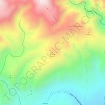
Morne Rouge topographic map
Interactive map
Click on the map to display elevation.
About this map
Name: Morne Rouge topographic map, elevation, terrain.
Average elevation: 295 m
Minimum elevation: 22 m
Maximum elevation: 606 m
Other topographic maps
Click on a map to view its topography, its elevation and its terrain.
Belle-Anse
Haïti > Département du Sud-Est > Commune Belle Anse
Belle-Anse, Commune Belle Anse, Arrondissement Belle-Anse, Département du Sud-Est, Haïti
Average elevation: 149 m
Presaille
Haïti > Département du Sud-Est > Commune Belle Anse > La Source
Presaille, 1re Baie d'Orange, La Source, Commune Belle Anse, Arrondissement Belle-Anse, Département du Sud-Est, Haïti
Average elevation: 1,367 m
Parc La Visite
Haïti > Département du Sud-Est > Commune Belle Anse
Parc La Visite, RD 402, 1re Baie d'Orange, Commune Belle Anse, Arrondissement Belle-Anse, Département du Sud-Est, SEGUIN, Haïti
Average elevation: 1,076 m