
Thank you for supporting this site ❤️
Make a donation
Make a donation
Shahimardan topographic map
Click on the map to display elevation.
Thank you for supporting this site ❤️
Make a donation
Make a donation
Shahimardan
Shakhimardan City Resort is situated at 1975m above sea level, 155 km from Ferghana, in the picturesque mountainous district. The Kuliqurbon or Blue Lake is seven kilometers southeast of Shakhimardan. It was formed in 1766 after a series of extreme earthquakes. The lake is located at an altitude of 1,724 metres. It's 170 m long, 60 m tall, 5–10 m deep. The cableway continues to the lake for two kilometres.
Thank you for supporting this site ❤️
Make a donation
Make a donation
About this map
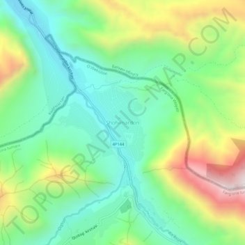
Name: Shahimardan topographic map, elevation, terrain.
Average elevation: 1,609 m
Minimum elevation: 1,306 m
Maximum elevation: 2,204 m
Thank you for supporting this site ❤️
Make a donation
Make a donation