
Thank you for supporting this site ❤️
Make a donation
Make a donation
Clear Creek topographic map
Click on the map to display elevation.
Thank you for supporting this site ❤️
Make a donation
Make a donation
About this map
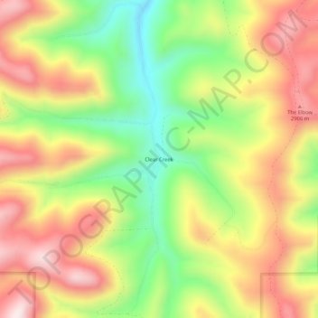
Name: Clear Creek topographic map, elevation, terrain.
Location: Clear Creek, Carbon County, Utah, United States (39.62580 -111.17239 39.66580 -111.13239)
Average elevation: 2,726 m
Minimum elevation: 2,466 m
Maximum elevation: 2,978 m
Thank you for supporting this site ❤️
Make a donation
Make a donation
Other topographic maps
Click on a map to view its topography, its elevation and its terrain.
Scofield Reservoir
United States > Utah > Carbon County
Scofield Reservoir is a 2,815-acre (11.39 km2) reservoir impounded by Scofield Dam, in Carbon County, Utah. Located on the Price River, a tributary of the Green River, Scofield Reservoir is adjacent to northernmost boundary of the Manti–La Sal National Forest. The reservoir sits at an elevation of 7,618 feet…
Average elevation: 2,435 m