
Thank you for supporting this site ❤️
Make a donation
Make a donation
Monrovia topographic map
Click on the map to display elevation.
Thank you for supporting this site ❤️
Make a donation
Make a donation
About this map
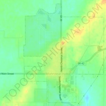
Name: Monrovia topographic map, elevation, terrain.
Location: Monrovia, Morgan County, Indiana, United States (39.57155 -86.49194 39.59672 -86.46542)
Average elevation: 237 m
Minimum elevation: 222 m
Maximum elevation: 256 m
Thank you for supporting this site ❤️
Make a donation
Make a donation
Other topographic maps
Click on a map to view its topography, its elevation and its terrain.