
Make a donation
Harrison Township topographic map
Click on the map to display elevation.
Make a donation
About this map
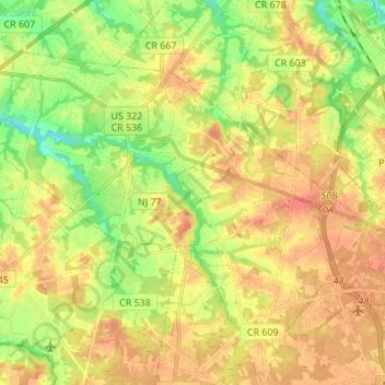
Name: Harrison Township topographic map, elevation, terrain.
Average elevation: 31 m
Minimum elevation: 2 m
Maximum elevation: 56 m
Make a donation
Other topographic maps
Click on a map to view its topography, its elevation and its terrain.
Franklinville
United States > New Jersey > Gloucester County > Franklin Township
Average elevation: 32 m
Make a donation
Monroe Township
United States > New Jersey > Gloucester County > Monroe Township
Average elevation: 38 m
Make a donation
Clarksboro
United States > New Jersey > Gloucester County > East Greenwich Township
Average elevation: 14 m
Buckingham Village
United States > New Jersey > Gloucester County > Mantua Township
Average elevation: 24 m
Make a donation
Mantua Creek
United States > New Jersey > Gloucester County > West Deptford Township
Average elevation: 13 m
Mickleton
United States > New Jersey > Gloucester County > East Greenwich Township
Average elevation: 18 m
Hurffville
United States > New Jersey > Gloucester County > Washington Township > Hurffville
Average elevation: 26 m
Make a donation
Sunset Beach
United States > New Jersey > Gloucester County > Deptford > Sunset Beach
Average elevation: 17 m
Bridgeport
United States > New Jersey > Gloucester County > Logan Township > Bridgeport
Average elevation: 4 m
Westcotville
United States > New Jersey > Gloucester County > Deptford Township
Average elevation: 16 m