
Make a donation
Pacific Palisades topographic map
Click on the map to display elevation.
Make a donation
Pacific Palisades
Pacific Palisades was formally founded in 1921 by a Methodist organization, and in the years that followed became a refuge for Jewish artists and intellectuals fleeing the Holocaust. The Palisades would later be sought after by celebrities and other high-profile individuals seeking privacy. It is known for its seclusion and for being a close-knit community with a small-town feel, as well as its Mediterranean climate, hilly topography, natural environment, and abundance of parkland and hiking trails, 3-mile (4.8 km) strip of coastline, and for being home to a number of architecturally significant homes.
Make a donation
About this map
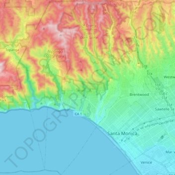
Name: Pacific Palisades topographic map, elevation, terrain.
Average elevation: 196 m
Minimum elevation: -2 m
Maximum elevation: 653 m
Make a donation
Other topographic maps
Click on a map to view its topography, its elevation and its terrain.
San Fernando Valley
United States > California > Los Angeles County > Los Angeles
Average elevation: 496 m
Universal City Overlook
United States > California > Los Angeles County > Los Angeles
Average elevation: 278 m
Make a donation
San Fernando Valley
United States > California > Los Angeles County > Los Angeles
Average elevation: 496 m
Will Rogers State Historic Park
United States > California > Los Angeles County > Los Angeles
Average elevation: 152 m
South Los Angeles
United States > California > Los Angeles County > Los Angeles
Average elevation: 421 m
Make a donation
El Escorpion Park
United States > California > Los Angeles County > Los Angeles
Average elevation: 341 m
San Fernando Valley
United States > California > Los Angeles County > Los Angeles
Average elevation: 496 m
Make a donation
Rio de Los Angeles State Park State Recreational Area
United States > California > Los Angeles County > Los Angeles
Average elevation: 141 m
Make a donation