
Tours topographic map
Interactive map
Click on the map to display elevation.
About this map
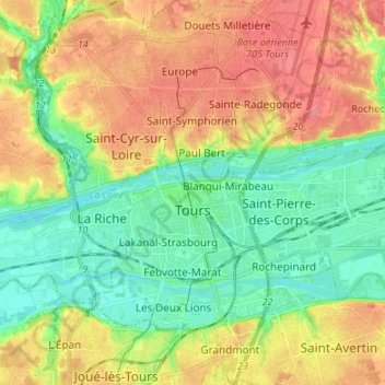
Name: Tours topographic map, elevation, terrain.
Average elevation: 73 m
Minimum elevation: 40 m
Maximum elevation: 116 m
Tours a une altitude minimale de 44 m et une maximale de 109 m, son altitude moyenne est de 77 m tandis que celle de sa mairie est de 52 m environ.
Other topographic maps
Click on a map to view its topography, its elevation and its terrain.
Saint-Jean-Saint-Germain
France > Centre-Val de Loire > Indre-et-Loire
Saint-Jean-Saint-Germain, Loches, Indre-et-Loire, Centre-Val de Loire, France métropolitaine, 37600, France
Average elevation: 111 m
Monts
France > Centre-Val de Loire > Indre-et-Loire
Monts, Tours, Indre-et-Loire, Centre-Val de Loire, France métropolitaine, 37260, France
Average elevation: 81 m
Saint-Cyr-sur-Loire
France > Centre-Val de Loire > Indre-et-Loire
Saint-Cyr-sur-Loire, Tours, Indre-et-Loire, Centre-Val de Loire, France métropolitaine, 37540, France
Average elevation: 83 m