
Thank you for supporting this site ❤️
Make a donation
Make a donation
Le Chevril topographic map
Click on the map to display elevation.
Thank you for supporting this site ❤️
Make a donation
Make a donation
About this map
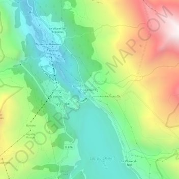
Name: Le Chevril topographic map, elevation, terrain.
Average elevation: 2,106 m
Minimum elevation: 1,545 m
Maximum elevation: 3,090 m
Thank you for supporting this site ❤️
Make a donation
Make a donation
Other topographic maps
Click on a map to view its topography, its elevation and its terrain.
Adduction EDF du Nant
France > Auvergne-Rhône-Alpes > Savoie > Tignes > Les Maisonnettes
Average elevation: 1,959 m
Thank you for supporting this site ❤️
Make a donation
Make a donation
Refuge du Palet
France > Auvergne-Rhône-Alpes > Savoie > Tignes > Val-Claret
Average elevation: 2,585 m
Barrage du Chevril
France > Auvergne-Rhône-Alpes > Savoie > Tignes > Le Chevril
Average elevation: 1,966 m