
Thank you for supporting this site ❤️
Make a donation
Make a donation
Les Jeandiats topographic map
Click on the map to display elevation.
Thank you for supporting this site ❤️
Make a donation
Make a donation
About this map
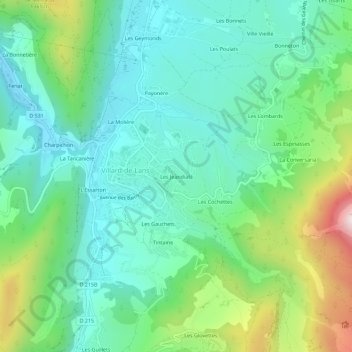
Name: Les Jeandiats topographic map, elevation, terrain.
Average elevation: 1,128 m
Minimum elevation: 940 m
Maximum elevation: 1,631 m
Thank you for supporting this site ❤️
Make a donation
Make a donation
Other topographic maps
Click on a map to view its topography, its elevation and its terrain.
Lac de la Moucherolle
France > Auvergne-Rhône-Alpes > Isère > Villard-de-Lans
Average elevation: 1,815 m