
Sydney topographic map
Click on the map to display elevation.
Sydney
The Hills district generally refers to the suburbs in north-western Sydney including the local government areas of The Hills Shire, parts of the City of Parramatta Council and Hornsby Shire. Actual suburbs and localities that are considered to be in the Hills District can be somewhat amorphous and variable. For example, the Hills District Historical Society restricts its definition to the Hills Shire local government area, yet its study area extends from Parramatta to the Hawkesbury. The region is so named for its characteristically comparatively hilly topography as the Cumberland Plain lifts up, joining the Hornsby Plateau.
About this map
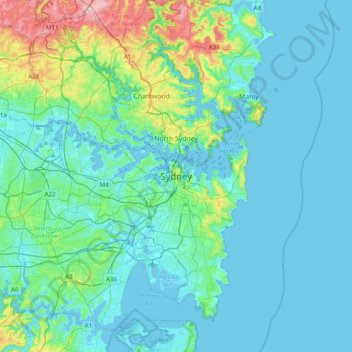
Name: Sydney topographic map, elevation, terrain.
Average elevation: 32 m
Minimum elevation: -6 m
Maximum elevation: 212 m
Other topographic maps
Click on a map to view its topography, its elevation and its terrain.