Geolocate

Veneto topographic map

Interactive map

Click on the map to display elevation.

Veneto

The climate changes significantly from one area to another: while it is continental on the plains, it is milder along the Adriatic coast; around the Lake Garda and in the hilly areas. The lowlands are often covered by thick fog, in Winter; precipitations that are scarce – 750 mm per year – close to the river Po, but are more abundant – from 750 to 1100 mm per year – at higher altitudes; the highest values – up to 3200 mm per year – are recorded in the Bellunese Prealps, near Mount Pasubio and on the Asiago plateau.

Wikipedia (CC-BY-SA 3.0)

About this map

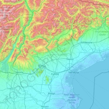
Name: Veneto topographic map, elevation, terrain.

Location: Veneto, Italy (44.79243 10.62310 46.68062 13.10217)

Average elevation: 587 m

Minimum elevation: -7 m

Maximum elevation: 3,832 m

Other topographic maps

Click on a map to view its topography, its elevation and its terrain.

Balestrino

Italy > Liguria > Savona

Average elevation: 426 m

Florence

Italy > Tuscany > Florence

Average elevation: 142 m

Castropignano

Italy > Molise > Campobasso

Average elevation: 561 m

Moncenisio

Italy > Piedmont > Torino

Average elevation: 1,755 m

Arina

Italy > Veneto > Arina

Average elevation: 744 m

Asolo

Italy > Veneto > Asolo

Average elevation: 132 m

Cuneo

Italy > Piemont > Cuneo

Average elevation: 510 m

Pantani

Italy > Cerreto Laziale

Average elevation: 428 m

Bondo

Italy > Trentino-Alto Adige/Südtirol > Bondo

Average elevation: 1,040 m

Logo

Italy > Lombardy > Logo

Average elevation: 68 m

Como

Italy > Lombardy

Average elevation: 706 m

Rimini

Italy > Emilia-Romagna

Average elevation: 159 m

Verona

Italy > Veneto > Verona

Average elevation: 137 m

Monza

Italy > Lombardy > Monza

Average elevation: 175 m

Melendugno

Italy > Apulia > Melendugno

Average elevation: 38 m

Castro

Italy > Apulia > Castro

Average elevation: 51 m

Afragola

Italy > Campania > Afragola

Average elevation: 43 m

Trento

Italy > Trentino-Alto Adige/Südtirol > Trento

Average elevation: 786 m

Fiumicino

Italy > Lazio > Fiumicino

Average elevation: 37 m

Gravere

Italy > Piemont > Gravere

Average elevation: 1,393 m

Molino Nuovo

Italy > Lombardy > Molino Nuovo

Average elevation: 48 m

Limone Piemonte

Italy > Piemont > Limone Piemonte

Average elevation: 1,618 m

Massa

Italy > Tuscany > Massa

Average elevation: 391 m

Genoa

Italy > Liguria > Genoa

The city of Genoa covers an area of 243 square kilometres (94 sq mi) between the Ligurian Sea and the Apennine Mountains. The city stretches along the coast for about 30 kilometres (19 mi) from the neighbourhood of Voltri to Nervi, and for 10 kilometres (6.2 mi) from the coast to the north along the valleys…

Average elevation: 333 m

San Damiano Macra

Italy > Piemont > San Damiano Macra

Average elevation: 1,258 m

Crocifisso

Italy > Marche > Crocifisso

Average elevation: 191 m

Volterra

Italy > Tuscany > Volterra

Average elevation: 228 m

Fermignano

Italy > Marche > Fermignano

Average elevation: 344 m

Floresta

Italy > Sicily > Floresta

Average elevation: 1,255 m

Laghetto Dell Alpe

Italy > Lombardy > Valfurva

Average elevation: 2,653 m

9

Italy > Lombardy > Convento Padri Cappuccini

Average elevation: 196 m

Courmayeur

Italy > Aosta Valley > Courmayeur

At an elevation of 1,224 m (4,016 ft) above sea level, it is located at the foot of the southern side of Mont Blanc, at 4,810 m (15,781 ft) the highest point in the Alps and western Europe (see Seven Summits), and is crossed by the Dora Baltea (fr. Doire baltée) river.

Average elevation: 2,366 m

Baiso

Italy > Emilia-Romagna > Baiso

Average elevation: 438 m

Marsala

Italy > Sicily > Marsala

Average elevation: 22 m

Valtournenche

Italy > Aosta Valley > Valtournenche

Average elevation: 2,640 m

Quartiere 1

Italy > Tuscany > Florence

Average elevation: 77 m

Chiaverano

Italy > Piemont > Chiaverano

Average elevation: 461 m

Monteiasi

Italy > Apulia > Monteiasi

Average elevation: 52 m

Castel del Piano

Italy > Tuscany > Castel del Piano

Average elevation: 561 m

VI Circoscrizione

Italy > Sicily > Palermo

Average elevation: 224 m

Tagliacozzo

Italy > Abruzzo > Tagliacozzo

Average elevation: 1,045 m

Municipio Roma I

Italy > Lazio > Rome

Average elevation: 51 m

Baudini

Italy > Piemont > Baudini

Average elevation: 508 m