
Thank you for supporting this site ❤️
Make a donation
Make a donation
Dhuy topographic map
Click on the map to display elevation.
Thank you for supporting this site ❤️
Make a donation
Make a donation
About this map
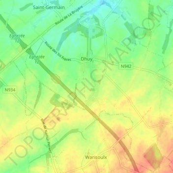
Name: Dhuy topographic map, elevation, terrain.
Location: Dhuy, Eghezée, Namen, Wallonië, België (50.53090 4.83274 50.57423 4.90197)
Average elevation: 171 m
Minimum elevation: 148 m
Maximum elevation: 195 m
Thank you for supporting this site ❤️
Make a donation
Make a donation
Other topographic maps
Click on a map to view its topography, its elevation and its terrain.